


Union Voting District, Barton County, Missouri
About
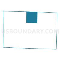
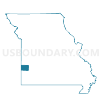
Outline

Summary
| Unique Area Identifier | 607074 |
| Name | Union Voting District |
| County | Barton County |
| State | Missouri |
| Area (square miles) | 36.12 |
| Land Area (square miles) | 35.90 |
| Water Area (square miles) | 0.22 |
| % of Land Area | 99.40 |
| % of Water Area | 0.60 |
| Latitude of the Internal Point | 37.61060760 |
| Longtitude of the Internal Point | -94.31119670 |
Maps

Graphs
Select a template below for downloading or customizing gragh for Union Voting District, Barton County, Missouri


Neighbors
Neighoring Voting District (by Name) Neighboring Voting District on the Map
- Barton City Voting District, Barton County, MO
- Bronaugh School Voting District, Vernon County, MO
- Central Voting District, Barton County, MO
- Doyles Port Voting District, Barton County, MO
- Lamar Voting District, Barton County, MO
- Sheldon Community Building Voting District, Vernon County, MO
Top 10 Neighboring County Subdivision (by Population) Neighboring County Subdivision on the Map
- Lamar township, Barton County, MO (1,490)
- Drywood township, Vernon County, MO (1,387)
- Moundville township, Vernon County, MO (788)
- Central township, Barton County, MO (561)
- Dover township, Vernon County, MO (529)
- Union township, Barton County, MO (507)
- Barton City township, Barton County, MO (250)
- Doylesport township, Barton County, MO (231)
Top 10 Neighboring Place (by Population) Neighboring Place on the Map
Top 10 Neighboring Unified School District (by Population) Neighboring Unified School District on the Map
- Lamar R-I School District, MO (7,415)
- Liberal R-II School District, MO (2,982)
- Bronaugh R-VII School District, MO (1,429)
- Sheldon R-VIII School District, MO (1,154)
Top 10 Neighboring State Legislative District Lower Chamber (by Population) Neighboring State Legislative District Lower Chamber on the Map
Top 10 Neighboring State Legislative District Upper Chamber (by Population) Neighboring State Legislative District Upper Chamber on the Map
Top 10 Neighboring 111th Congressional District (by Population) Neighboring 111th Congressional District on the Map
Top 10 Neighboring Census Tract (by Population) Neighboring Census Tract on the Map
- Census Tract 9602, Barton County, MO (4,104)
- Census Tract 9506, Vernon County, MO (3,092)
- Census Tract 9601, Barton County, MO (2,986)